There’s a fair bit of sun still but rain and drizzle squalls constantly roll in from the west and south-west, the wind determines whether progress is made, or not.
An Laimhrig is Gaelic for ‘anchorage’ or ‘safe haven’ - the name given to the community buildings at Eigg’s harbour. They embrace a café, gift shop, groceries, bike and kayak hire as well as an adjacent building with showers, laundry and drying room.
Since our last visit in 2019 £1.2 million has been spent on upgrading An Laimhrig for the benefit of locals and tourists alike. Reopening last year it certainly offered a safe haven for us and our needs. High tech too, no fiddling with £ coins for showers and laundry, just swipe your card.

All the comforts of home. Hot chips, beer, guide books, maps and mobile reception for wx forecasts.
 Looking north-west to the cloud topped mountains of Rum from near the 400m summit of An Sgùrr on Eigg.
With clean bodies, clothes and a food restock we launched for a stormy crossing to Loch Scresort on Rum.
Arriving at high tide we tried to find a wild camp away from the head of the loch. With a ~3m tidal range the shallow rocky shore would dry a long way out at low tide, leaving us dependent on high tide for our departure. There was nowhere. Different geology and vegetation from our previous year lovely camping on machair. A rocky foreshore and rough very tussocky grassland behind, it was like trying to find a tent spot on a button grass plain.
Closing in on the official campground we spotted a patch of sand and although we knew departure would be somewhat tide dependent decided it would have to do. It turned out very ok, easy to get the boat above HW, a short carry and a little day shelter for campers, but at £25 a night a very expensive patch of grass!
The boat dried nicely in the breeze and intermittent sunshine that afternoon enabling a patch to be glassed over a hole we’d put in the hull when leaving Eigg that morning.
Rum’s mountainous skyline dominates the view from just about anywhere around the The Small Isles, they loomed impressively over our camp on the shores of Loch Scresort too. The scramble along the Rum Cuillin ridge attracts the more intrepid walkers and the many low level walk options draw in everyone else. Then there’s the bird watchers. Between 1975 and 1985 82 young white breasted sea eagles from Norway were reintroduced to the island. There’s also a colony of 60,000 pairs of Manx shearwaters.
The island is now owned and managed by NatureScot for long term ecological studies particularly of red deer.
Like much of the rest of the west coast of Scotland, Rum’s indigenous population of ~400 was evicted during the clearances in the early 1800’s to enable sheep grazing and the creation of a sporting estate for the rich English land owners.
Loch Scresort is dominated by Kinloch Castle, built in 1900 it stands as an idiosyncratic testament to extreme wealth. Technologically advanced for the time with a phone system, its own power supply, modern plumbing but also pet alligators in a heated aquarium.
Kinloch Castle is now closed and abandoned. There used be tours of the building and part of it was used as a hostel, where for a premium over the cost of a dorm bunk, bedrooms with four poster beds were available.
Despite being closed and half heartedly fenced off who could resist squeezing through the fencing and peering through the windows?


For some, its grounds for Heritage listing are not so much for architectural merit but more for its representation of a certain type of social lifestyle that existed in the era it was constructed.
Others are not so keen.
Jim Crumley, a Scottish nature writer, described Kinloch Castle as "a monument to… colossal wealth and ego and acquisitive greed… It is a building without a redeeming feature.. a loathsome edifice. It perpetuates only the memory of the worst kind of island lairds… a hideous affront, but nothing that a good fire and subsequent demolition couldn’t rectify".
Me, well I think I’m with Jim.
The following day it was really wet and wild, we weren’t going anywhere even just 11km around the coast to camp at Kilroy beach to save another £25!
The next day though we were at Kilroy for a late lunch contemplating the next 5 or 6kms to Guirdil. Even on the sheltered north-eastern shore of Rum we’d been pushing into a reasonable headwind but
we’d been making good progress
on smooth seas. We knew though that as soon as we rounded the headland west of Kilroy it would be full on, straight into the south-westerly wind, sea and swell. At least the sun was shining.

It wasn’t long though before we were pulling the boat up the steep pebbly beach out of reach of the surging waves. Or at least trying to. With feet slipping in the wet pebbles down towards the sea with every heave of the boat up the beach it was a three steps forward, two steps back effort.


Despite its homely comforts we’re generally happier in our tent, the bothy was a lot further away from the kayak too, so we soon set up amongst the ruined settlement next door.


A piece of bloodstone with Bloodstone Hill in the background. Sorry for the poor photo, pushing the depth of field capabilities of an iphone camera.
We got chatting to an archaeologist staying in the bothy who told us about bloodstone, (confusing name as it’s jade green in colour not red). Bloodstone was sought after in Neolithic times for axe and arrow heads. Only found at Bloodstone Hill on Rum it was traded throughout the west coast of Scotland.
Despite the forecast 10-15kn south-westerlies it was completely calm in the morning though the wind did pick up a bit as we crossed to Canna.
An easy half an hour or so later and we we bobbing around off the sea stacks Dùn Mòr and Dùn Beag (Gaelic
Mòr = big, Beag = small) surrounded by puffins. The air full of them wizzing past with a frantic whirring of wings, many others floating contentedly around us. The summits of the sea stacks were busy with puffins constantly coming and going from their burrows in the thin layer of soil topping the impressive igneous stacks.
Dùn Mòr and Dùn Beag from the sea. 
And the next day from the cliff tops, Rum just visible through the drizzle.
The bombproof anchorage of Canna harbour.
Views from our campsite on Canna. Looking west over the beach where we landed, sse to Rum and east to a rocky prow with Castle No. 11 (Coroghon Castle/Prìosan á Chorra-Dhùin)
perched on its side.
 The Canna community shop is only a few minutes walk from our tent. It’s small but well stocked and has free wifi as there’s no mobile reception on the island. Just what we need as the way the forecasts are looking we'll be here for at least a couple of days. The shop, open 24 hours, works on an honesty system. If paying by cash just put your money in the till and help yourself to change, paying by card punch the total into the eftpos machine and swipe.
Returning to camp with full water containers along what is called Saturnino’s path.
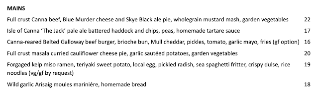 The Canna Cafe, we can thoroughly recommend the Canna beef pie!!


 Rhuvaal lighthouse.

