We really could not have scored a better day for crossing from Milovaig on Skye to the isle of Ronay, NE of Benbecula. The distance is almost exactly the same as Banks Strait between Musselroe in NE Tasmania and Clarke Island in The Furneaux Group, similar tidal flows too. We’ve crossed Banks Strait a good few times but there was a tad more nervousness for this crossing. Unfamiliar waters maybe but perfect weather forecasts. The Windy app was giving us variable winds from the SE of up to 8knots, the Inshore Waters forecast was giving us variable winds too, from the NE, Force 3 or 4. Either would do very nicely thank you. Both forecasts meant with the wind behind us we’d be sailing, but if we had a choice the Inshore Waters would come first as we’d be sailing even faster. The wind strength and direction might be uncertain but what was certain, given the general situation, was a hot sunny day.

The evening before we left Lynne got chatting with a fella at the Milovaig jetty. Once she mentioned we were kayaking he insisted on coming over to inspect our boat and chat all things kayaking as it turned out he had been sea kayaking for 30 years including a solo circumnavigation of the UK in 1994. He was out in his inflatable the next morning fishing and gave us a wave as we headed offshore.
As it turned out neither forecast was quite right, the wind was NE as the Inshore Forecast predicted but Windy picked the strength, just enough to fill both sails and give us a little boost. We’d left about 10am which according to the Tidal Atlas would put us roughly in the middle of the crossing at slack water between the Southerly ebb and the Northerly flood. As it turned out we didn’t come across any perceptible tidal flow, and our track followed the straight line route on the GPS very closely simply by aiming for a prominent hill on North Uist all the way across.
Without a cloud in the sky we paddled meditatively on without a care in the world. We could feel by the lessened load on our paddle blades that the sails were helping us along just nicely.
Far to south we spotted a large freighter, heading north. Knowing we were crossing shipping separation lanes I repeated the mantra learnt as a kid crossing the road, “Look right, look left, look right again”, adding a contemporary “Then paddle like hell!”
A few checks of its position over the next few minutes confirmed the ship was going to pass well ahead of us.
A little while later Lynne spotted another, heading south. This one too was going to pass ahead of us, but much closer than the previous ship. We headed more northerly and slowed down to increase the distance between us. It rumbled across our bows about 1.5km ahead of us.
Back on our original course we paddled on until ‘smoko’ time, about 2 1/2 hours from leaving the beach in Skye. We were ready for a break and something to eat, the GPS told us we had about 5km to go and while sitting there relaxing and eating the light North Easterly was pushing us along at about 4kph.
I had checked out the east coast of Benbecula and the adjacent coastline on Google Earth for landing opportunities at some point. The continuous rocky shoreline seemed very uninviting with few if any beaches of any sort. I thought it can’t be that bad, there’ll always be something. Well I was wrong, it was worse.
Eventually, at about 1:30 we found a bouldery beach that enabled us to clamber out and pull the bow of the boat up on the rocks. We stretched our legs and had a pee, and were tempted to linger longer and have a cup of coffee, but having just had a break we thought we’d carry on a bit further. Which we did. A bit further, and a bit further and further still as every headland, every corner, every bay just revealed more uninviting rocky coastline. There were a few pebbly beaches but once close they were all guarded by seaweed covered rock shelves or boulder fields. Finally, a couple of hours later, and by now really needing a coffee, food and a rest, we found a bouldery beach with no offshore rocks, just seaweed. I pulled the rudder up and we glided into the seaweed.
And stopped dead.
It was so thick and the water too deep we couldn’t even get out, let alone pull our the boat through it to the beach, 5m away.
There was nothing for it, out came the standby food that lives behind my seat, a tin of baked beans and a tin of rice cream.
The map showed a sandy beach on the Southern side of a small island, so we navigated the maze of skerries only to find a mass of boulders.
Onward, but by now time was getting on and we were looking not just for a rocky beach to pull the bow up but a proper landing place where we could get the heavily laden boat right out of the water and camp. This was not looking too hopeful until eventually in the distance we spotted the Petersport jetty/boat ramp and on a knoll above the clutter of ropes, buoys and pots was a lovely spot for the tent.
After nearly 50km with only one break ashore of 15-20mins the end of day dram of Jura malt never tasted so good.

Heading south the next day into 15kn Southerlies we landed in the SE facing bay of Bàgh Uisinis with its comfy bothy looked after by the Mountain Bothies Association. By the time we were back on the water the wind had all but dropped away so we made good time to the entrance of Lochboisdale. It was well past lunch and we were looking for a landing spot, hah! We discussed heading into Lochboisdale itself knowing there would be a boat ramp/jetty but the extra few kms in, then back out again wasn’t attractive.
Luckily on the southern shore alongside a steep rocky gulch we were able to climb straight out of our cockpits up onto the rocks without the need to beach the kayak at all.
The map showed a number of small sandy beaches on the Northern shore of Eriskay, and this time it did not let us down. We pulled ashore just on high tide on peerless white sand and just meters away a perfect spot for the tent on beautifully flat machair.
“Nae midges” I shouted over the roar of the wind and the buffeting, flapping tent. It’s become a bit of a catch phrase on this trip as when we can we’ll always camp on a high point so as to catch the slightest of breeze to help keep the ‘wee beasties’ at bay. It also has advantage of panoramic views.
So far this has worked very well with only a couple of mornings of midge terror in three weeks paddling.
Even before we’d landed at our perfect white sand beach I’d realised we were only a couple of kms from the ‘Am Politician’, the Eriskay pub. The thought of a pint or two and a pub meal only half an hour’s walk away.…well.
For smelly, salt encrusted, hungry and thirsty sea kayakers the pub would at least sort out the two most important of the four.
The SS Politician is the name of the vessel that went aground off Eriskay in 1941 carrying a huge cargo of malt whisky. The locals of course thought this manna from heaven was wonderful; the Police and Excise officials less so. The story of the SS Politician and the horde of whisky is told by the book and film “Whisky Galore”.
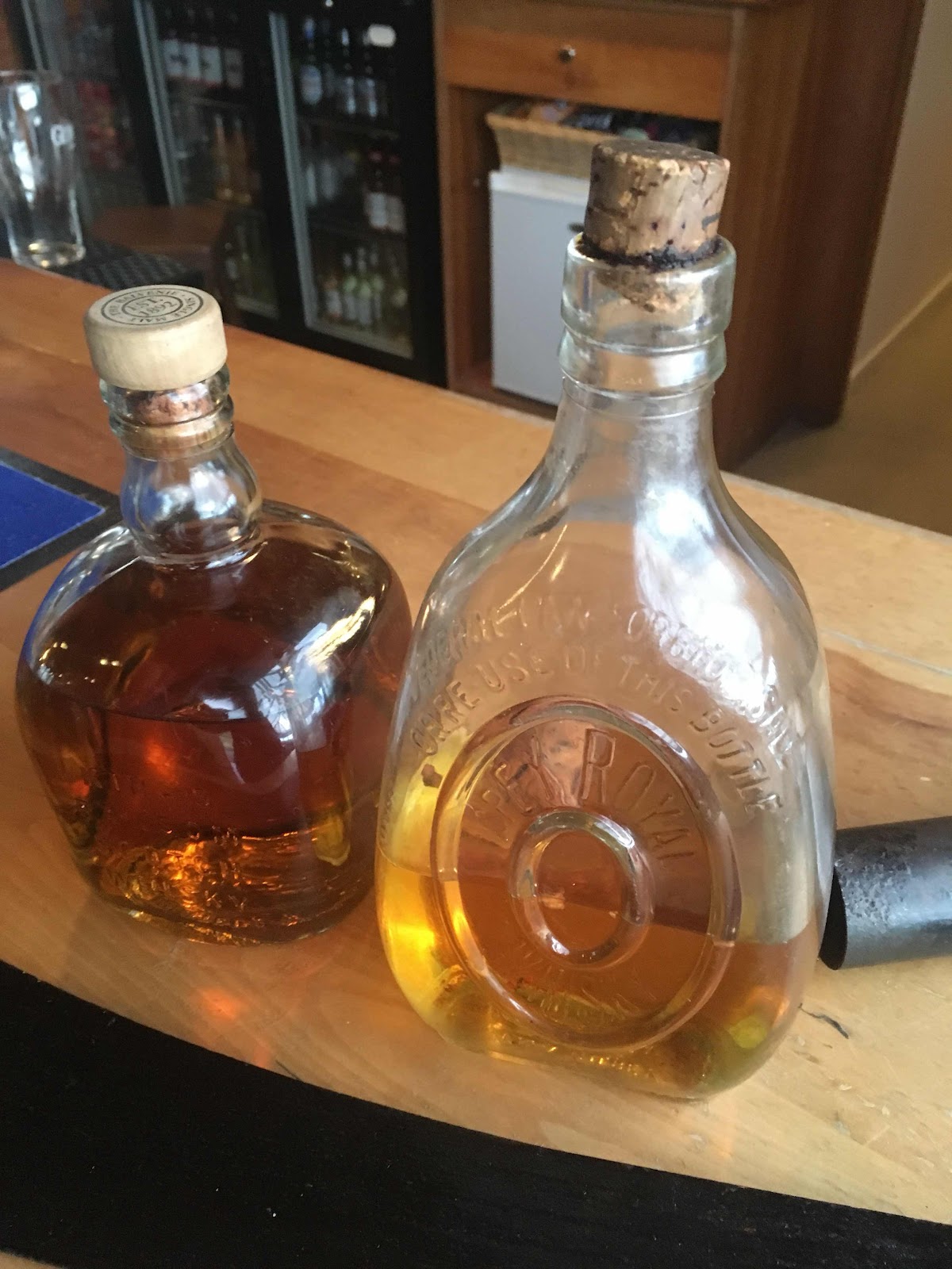
Whisky bottles from the ship SS Politician, the bottle on the right still containing the original whisky.
With the pub wifi enabling contact with the outside world I had confidently messaged a mate near Fort William that we’d be in Castlebay the next day. Only 25 kms away and Castlebay would sort out the smelly and salt encrusted parts of us that the pub couldn’t. But that was before we checked the weather. Ah, right, maybe I spoke too soon.
The Inshore Forecast predicted W or SW 5 or 6 and Windy’s forecast was a mass of the angry looking hues that indicate without any further detail that little, if any, progress was going to be made the next day. The general situation with a low passing close to the NW of us confirmed the predicted winds.
We’re always hopeful, maybe on the lee side of the islands we’ll have enough shelter to make more than head banging progress into the wind, maybe it’ll just blow for a few hours and then drop out. The night brought thunder and lightning, torrential rain and gusts strong enough for me to check that our dry suits, life jackets and spray decks stacked neatly outside the tent doors weren’t in danger of blowing away. They weren’t, but “Nae midges” I shouted into the night over our gale swept knoll.
The alarm at 6 went unheeded apart from to turn over and go back to sleep. At least the morning, if not the rest of the day in the tent, plenty of time to satiate Lynne’s new found Archers addiction with the Sunday omnibus edition on Radio 4.
Our campsite on the NE tip of Eriskay.

Sunday went quickly even though we were pinned down by South Westerly gales. Reading, knitting, Radio 4, snoozing and being largely a dry day out and about exploring the nearby coastline. During the night the wind veered North Westerly and is still blowing as strong as ever. With no phone and barely any VHF reception for a forecast we may have to go to the Am Politician again for their wifi.
No comments:
Post a Comment